Join 500K+ Users Who Fixed Their Signal in Stoneham
Compare coverage from all major carriers and find the strongest signal areas in Stoneham in under 30 seconds.
✓ Rated 4.8★ by 50K Users ✓ Works Offline ✓ Free Download

Find the best cell tower coverage in Stoneham, Massachusetts. Whether you're experiencing dropped calls, slow data, or weak signal strength, our comprehensive coverage maps help you locate nearby cell towers and find areas with the strongest mobile reception.
Compare coverage from all major carriers and find the strongest signal areas in Stoneham in under 30 seconds.
✓ Rated 4.8★ by 50K Users ✓ Works Offline ✓ Free Download
Select a carrier below to view detailed coverage maps and tower locations in Stoneham:
View AT&T cell towers and coverage areas in Stoneham. Find the best signal strength locations.
View Verizon cell towers and coverage areas in Stoneham. Find the best signal strength locations.
View T-Mobile cell towers and coverage areas in Stoneham. Find the best signal strength locations.
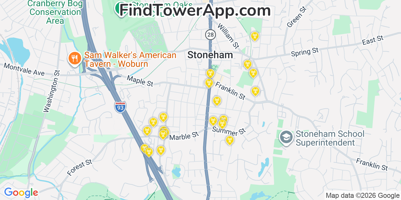
Our database maps 20 towers within range of Stoneham, Massachusetts (11 4G LTE, 7 3G, 1 2G, 1 5G), the closest 0.7 mi from the centre and 0.8 mi on average, out of roughly 269,795 towers across all networks in the wider area. The nearest tower is about 0.7 mi out, so outdoor signal is usually reliable while indoor reception can dip inside shielded buildings.
| # | Network | Type | Distance | Direction |
|---|---|---|---|---|
| 1 | T-Mobile | 4G LTE | 0.7 mi | S |
| 2 | Verizon | 2G | 0.7 mi | SW |
| 3 | AT&T | 3G | 0.8 mi | SW |
| 4 | AT&T | 3G | 0.8 mi | SW |
| 5 | AT&T | 3G | 0.8 mi | SW |
| 6 | AT&T | 3G | 0.8 mi | SW |
| 7 | T-Mobile | 3G | 0.8 mi | SW |
| 8 | Verizon | 4G LTE | 0.8 mi | SW |
| 9 | AT&T | 3G | 0.8 mi | SW |
| 10 | AT&T | 3G | 0.8 mi | SW |
| 11 | T-Mobile | 4G LTE | 0.8 mi | SW |
| 12 | Verizon | 4G LTE | 0.8 mi | SW |
Tower positions are approximate, derived from public cell-ID observations; open the FindTower app for live signal at your location.
Join thousands of Massachusetts residents who've improved their connectivity with FindTower.
✓ Free Download ✓ Works Offline ✓ All Massachusetts Cities
Explore coverage maps for other cities near Stoneham in Massachusetts:
View cell tower coverage maps for Pocasset
View cell tower coverage maps for Raynham Center
View cell tower coverage maps for Williamsburg
View cell tower coverage maps for Ware
View cell tower coverage maps for Erving